
Page 159 - Mapping the Nation: Taking Climate Action
P. 159
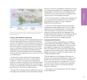
The Jack and Laura Dangermond Preserve protects an important biodiversity hot spot surrounding Point Conception, California. Map courtesy of The Nature Conservancy. Creating a New Model for Conservation Some of the very first maps TNC created decades ago using GIS technology marked this place as a priority for protection. Since then, the organization has purchased and conserved 125 million acres of land in 70 countries. Now TNC has established the Point Conception Institute to harness the power of open science to tackle urgent challenges related to climate change and biodiversity loss. The institute fosters diverse research collaborations with data stewardship and sharing and applies innovative technical and geospatial solutions that use this land as a living laboratory. The idea of the institute came from the need to explore, measure, study, and learn from this last coastal wilderness in California. "There's a real opportunity to develop a new model for conservation, using open science to establish legacy datasets that can be brought together with other data streams to create a true interdisciplinary collaborative effort," said Mark Reynolds, director of the Point Conception Institute. Although TNC was already using GIS widely, the donation by the Dangermonds cemented a triumvirate of partners. Nearby University of California, Santa Barbara, already had a Jack and Laura Dangermond endowed chair in geography with world- leading experts in GIS, and now it has an endowed chair in conservation science with an emphasis on leading innovative research projects on the Dangermond Preserve. The aim of these partners, including solution engineers from Esri, is to gather the many dimensions of Point Conception quickly because the impacts of climate change and biodiversity loss are quickening. In the face of climate change, ecotones are particularly important because they represent the front lines of habitat ranges that are constantly expanding or contracting. Ever in flux, the existence of infrastructure such as oil fields or subdivisions can prevent species from migrating to more favorable habitats and increases the risk of population decline or extinction. Without these barriers, Point Conception is poised to preserve species that struggle elsewhere. Compiling Scientific Evidence Scientists have already compiled 90 layers of GIS data to capture details about the Dangermond Preserve, including its archaeology, wildlife, and vegetation. These layers create the foundation of a digital twin of the landscape that lives within GIS. Digital twins can be instrumental in helping land managers inventory existing conditions, identify relationships between the conditions that define ecological systems, and simulate landscape processes. With the digital twin of the Dangermond Preserve, the institute is out to understand the landscape, visualize it, and forecast what it will look like in the future, considering the human and natural impacts the area experiences. The aim is to not just inform biodiversity science but also understand the social, cultural, economic, environmental, and other dimensions of the place. "We're really in a race," Reynolds said. "All of this needs to be assimilated faster." 158 Biodiversity
