
Page 163 - Mapping the Nation: Taking Climate Action
P. 163
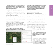
The modern fragmentation of the forests—through the introduction of roads, homes, croplands, and cities—has disrupted this cycle. Without fires, the forested areas that remain have become overgrown. The decline of fire-adapted forest ecosystems is not the only factor that threatens the gopher tortoise, but it underlines the complexity of the fight to protect the endangered creature. The South Carolina Natural Heritage Program is arguably their most powerful ally. Protecting South Carolina Heritage The Natural Heritage Program—and its Cultural Heritage counterpart, dedicated to preserving land with historical and cultural relevance—together form the South Carolina Heritage Trust Program, a section within the state's Department of Natural Resources (SCDNR). The work of the Heritage Trust began in the mid-1970s. Shortly thereafter, when the project was transferred to SCDNR, the state agency became the first state in the country dedicated to protecting land with abundant natural or cultural significance. From the start, the work relied on one of the earliest desktop GIS software programs. As GIS software grew more sophisticated, Heritage Trust adopted an ArcGIS Enterprise approach. The technology became central to many of the program's objectives, including mapping habitat loss and picking areas the state could purchase for permanently protected heritage preserves. With GIS, conservationists can analyze how and where to develop land to protect biodiversity. Shortening the "Long, Drawn-Out Process" The Natural Heritage Program recently expanded its GIS to facilitate better communication with stakeholders, including private developers, scientists, and the public. Communication and workflows have always been challenges, especially regarding due diligence for developers proposing new projects. Any development that receives federal government financing or permitting must review the presence of threatened or endangered species within the proposed project footprint. Until recently, developers would submit requests with varying degrees of specificity. Some contained only geographic coordinates, others included maps, and some were just general descriptions of the area. The office would check requests against its database of protected flora and fauna, struggling to get through around 200 requests per year. "It was a long, drawn-out process, and it wasn't even our full-time job," said Joe Lemeris, the program's GIS and data manager. The inefficiency extended to the workflow used by scientists who gathered data from the field. They recorded their observations on Excel spreadsheets or paper forms. At some later date, this information would become part of the program's database. The office also gathered data from other An interactive form with a map viewer helps developers submit plans for threatened or endangered species review. 162 Biodiversity
