
Page 164 - Mapping the Nation: Taking Climate Action
P. 164
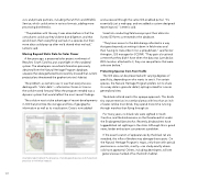
163 civic and private partners, including the US Fish and Wildlife Service, which could arrive in various formats, adding more processing bottlenecks. "The problem with the way it was done before is that the consultants could say they'd done due diligence, and that we'd shown them everything we had on a species, but then more data could pop up after we'd shared what we had," Lemeris said. Moving Beyond Static Data for Solar Power A few years ago, a proposed solar project northwest of Beaufort, South Carolina, put a spotlight on the outdated system. The developers consulted information previously obtained from the Natural Heritage Program database, unaware that data gathered more recently showed that current project plans threatened the gopher tortoise's habitat. The problem, as Lemeris saw it, was that everyone was dealing with "static data"—information frozen in time as the world moved forward. What the program needed was a dynamic system that would reflect the most recent findings. The solution was to take advantage of recent developments in GIS that prioritize the storage and flow of geographic information as well as its visualization. Data is now added A sample report details the presence of endangered species and shares best practices to minimize impacts and accessed through the same GIS-enabled portal. "It's essentially just a web app, and we added a custom-designed reporting tool," Lemeris said. Scientists conducting field surveys input their data into Survey123 forms connected to the database. "They have access to the data being collected in a way that goes beyond just writing it down in field notes and then having to transcribe it into a spreadsheet," said Tanner Arrington, GIS manager for SCDNR. "They gain a locational context that they didn't have when the data was just tabular. With location attached to it, they can see patterns that were unknown before." Protecting Species from Foot Traffic The GIS data can be presented with varying degrees of specificity, depending on who wants to see it. For certain species, the Natural Heritage Program prefers not to share its survey data in granular detail, opting instead for a more generalized view. The black rail bird merits this opaque approach. This bird's tiny stature restricts it to wetland areas with less than an inch of water. Unlike most birds, they spend more time running through marshes than flying through air. For many years, no black rails were sighted in South Carolina, and the bird remains on the threatened list under the Endangered Species Act. Recently, birdwatchers have logged black rail sightings in the state. Although this is good news, birder enthusiasm can present a problem. If the exact location of appearances by the black rail are revealed, the influx of birders may damage those spots. On the Natural Heritage Program's maps, only those with special permissions—scientists, mostly—can study exactly where rails have appeared. Others, including developers, will see general areas marked off as the bird's habitat.
