
Page 85 - Mapping the Nation: Taking Climate Action
P. 85
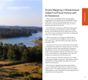
Drone Mapping in Mozambique Helps Find Flood Victims with AI Assistance Three cyclones, including two back-to-back, battered Mozambique in 2019, destroying more than 800,000 hectares (3,089 square miles) of farmland during harvest season. The devastation to crops and livelihoods left nearly two million people facing acute food insecurity. The UN World Food Programme (WFP) responded quickly, with two helicopters to ferry supplies and rescue stranded people. Given flooded roads, the air support was crucial but not nearly enough to distribute food and find stranded people across such a wide area of impact. "When your primary tool for flying over large bodies of water is a helicopter that costs $2,800 an hour, you need to find a better way," said Patrick McKay, drone data operations manager for WFP. The aftermath of Cyclone Idai in 2019 was the first time WFP coordinated a fleet of drones for disaster response. The timing was right because WFP had conducted drone training with Mozambique's Institute of Disaster Management (INGC) to build in-country drone pilot capacity. Also, Idai was an unusual storm in that it parked over land, dumped rain for days, and flooded an area spanning some 835 square miles. "Each time the pilots came back, they told us the flooded area had gotten bigger," McKay said. "They'd go by a stadium, and people were climbing higher and higher in the stands every time they flew past." The drone pilots mapped the damage and searched for survivors, freeing up helicopter pilots to conduct rescue and supply missions. The images and videos the drones collected fueled updates to maps created with GIS technology that let all responders see what was going on. 84 Inland Flooding
