
Page 86 - Mapping the Nation: Taking Climate Action
P. 86
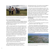
WFP conducted advanced drone training in Mozambique in September 2018. The in-country team put this knowledge to work quickly and improved its skills in repeated disasters. (Photo: WFP / Katarzyna Chojnacka) Drone Capacity Building in Mozambique Drones are now standard for every WFP emergency response, used early and often to find out how many buildings have been damaged and how far floodwaters reach, scout for survivors, and map changing conditions. WFP is usually among the first on the scene because it has offices in more than 120 countries and leads clusters of UN emergency telecommunications and logistics staff who need to go in and set up before other teams arrive. WFP's use of drones has helps UN Children's Fund (UNICEF) inspect schools, assists the World Health Organization (WHO) assess the status of clinics, and helps other UN organizations and in-country first responders rapidly understand conditions on the ground. GIS gathers drone-collected data—with details about people and structures—in maps and apps to meet each organization's mission. "Before, only the people with access to a helicopter could see the damage and do assessments," McKay said. "But now with drone pilots mapping in really high detail, down to two- centimeter resolution, we could share that information with everyone, and even do remote inspections." WFP worked directly with Antonio Jose Beleza, deputy national director of the National Institute of Disaster Management (INGC). Eight of the pilots came from the Mozambique government. They used their local knowledge to map where they thought people were and still might be. Drone teams met each morning, dispersed, and met in the evening to coordinate activities and process images to update maps. Evening meetings coordinated the next day's flights and the areas to cover. In the morning, the teams would assign people to ground vehicles, helicopters, and boats to reach flooded areas. The drone teams would check on villages, relate if they were flooded or clear, and document the people walking through floodwaters toward safety. Synthetaic Automates the Search for People Surrounded by Floodwaters Each drone flight can collect hundreds to thousands of images that need to be processed and reviewed to reveal the most urgent situations. "The faster we can go through them, the faster we can get to the people who need our help," McKay said. The cyclones in Mozambique in 2019 marked the first time that WFP used a model with artificial intelligence (AI) machine learning algorithms to automatically find and classify damage to buildings, which removed the need for people to look at every image. But to locate people, a team of 20 people had to train the AI model over six weeks to achieve accurate results. This was not a workable solution given the time-critical nature of search and rescue. Mozambique's Institute of Disaster Management used drones to respond to Cyclone Desmond, which caused devastating flooding in Beira in January 2019. Photo: INGC / Antonio Beleza 85
