
Page 88 - Mapping the Nation: Taking Climate Action
P. 88
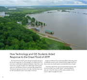
87 How Technology and GIS Students Aided Response to the Great Flood of 2019 The Great Flood of 2019 came during the wettest spring on US record, impacting 14 million people as multiple storms hit and rivers overflowed, flooding the Midwest, High Plains, and South from January through June. High-water mark records were set in 42 different locations along the Mississippi River. The lessons learned continue to this day—the flood was one for the record books across many areas of science. Students at Western Illinois University (WIU) in Macomb, which sits between and just north of where the Mississippi and Illinois Rivers meet, monitored impacts and identified areas of need. "The Mississippi River was having extreme flooding, and the Illinois River just couldn't drain," said Chad Sperry, director of the GIS Center at WIU and a member of the state incident management team.
